Contents
2.2
Non-construction Related Activities
2.3.2
Diversion of Submarine Aviation Fuel Pipelines
2.3.3
Diversion of Submarine 11kV Cables
2.3.4
Construction of Runway Approach Lights
2.3.5
Construction of Hong Kong International Airport Approach Area (HKIAAA)
Marker Buoys
2.4
Types of Working Vessels Involved
2.4.1
Non-self-propelled Vessels
2.4.3
Vessels Delivering Materials to and from the Project Site
2.5
Structure of the Updated Plan
3.2
Local and International Standards and Regulations
3.2.1
Water Pollution Control Ordinance (Cap. 358)
3.2.3
International Convention for the Prevention of Pollution from Ships
(MARPOL 73/78)
3.2.4
Marine Parks Ordinance (Cap.476)
3.2.5
Others Relevant Legislation and Requirements
3.3
Guidelines for Preventing Water Quality Impacts
3.3.2
Avoidance of Sediment Plumes
3.4 Specific Requirements for Managing
Marine Construction Activities
4 Practices or Measures to Keep
Construction-related Vessels to a Practical Minimum
4.3 Reduction of Waste Materials
4.4 Provision of Regular Trips of
Passenger Vessels Services
5 Predefined and Regular Routes for Construction
Vessels
5.1 Considerations of Setting Marine
Travel Route
5.1.1 Existing Navigation Channel and
Marine Traffic
5.1.2 Restricted Areas, Height Restriction
and Speed Limit
5.2
Design of Marine Travel Route for Construction Vessels
5.2.1
General Arrangements for Construction Vessels
5.2.2
Construction Vessels Transit Route
5.2.3
General Arrangements for Existing and Future Marine Facilities
5.2.4
Guidelines for Safe Vessel Operations Travelling Outside and Within the
Works Area
5.2.5
Contingency Arrangements
6 Skipper
Training and Guidelines for Safe Vessel Operations in the Presence of the CWDs
6.1
Impacts on CWDs and Precautionary Measures
6.3
Guidelines for Safe Vessel Operations in the Presence of the CWDs
7 Speed
Limit of 10-knot for Construction Vessels within Works Area & CWD Hotspots
7.3
Chinese White Dolphin “Hotspot” Areas
8 Implementation
and Monitoring
8.1
Method of Implementation and Monitoring before the Commissioning of
Three-runway System
8.1.1
Marine Traffic Monitoring Systems
8.1.3
Water Quality and Vessel Movement
8.2
Method of Implementation and Monitoring after the Commissioning of
Three-runway System
8.2.1
Updated Marine Traffic Monitoring Requirements
8.2.2
Marine Traffic Monitoring and Audit Procedures
8.2.3
Termination of the Updated Marine Traffic Monitoring and Audit
Appendix B Working Vessels Involved
in the Construction Activities
Appendix C Code of Conduct in the
Presence of Dolphins
Table
2-1: Indicative Working Vessels Involved in the Construction Activities
Figure
5-4a: Indicative Marine Travel Route After I-2RS and Before the Designation of
NLMP
Figure
5-4b: Indicative Marine Travel Route After the Designation of NLMP
Figure
5-5: Potential Routes to Typhoon Shelters
Figure 7-5a: Dolphin Habitat Index and Marine Travel
Routes Before I-2RS
Figure 7-5c: Dolphin Habitat Index and Marine Travel
Routes After the Designation of NLMP
Figure
8-1: Typical Marine Traffic Monitoring System
1
Introduction
1.1
Background
The Government of the Hong Kong
Special Administrative Region (HKSAR) approved in principle the adoption of the
Three-Runway System (3RS) as the future development option for Hong Kong
International Airport (HKIA) for planning purposes on 20 March 2012, and also
approved the recommendation of Airport Authority Hong Kong (AAHK) to proceed
with the statutory environmental impact assessment (EIA). An EIA study
brief (ESB-250/2012) for the 3RS project (henceforth referred to as the
‘project’) was issued by the Environmental Protection Department (EPD) on 10
August 2012. The EIA report has been prepared according to the EIA study
brief requirements, which identified 12 key environmental assessment aspects to
be addressed as part of the EIA study. On 7 November 2014, the EIA for
the project (EIA Register No.: AEIAR-185/2014) was approved and an
Environmental Permit (EP) (Permit No.: EP-489/2014) was issued for the
project. The project locations with indication of land formation area
including area reserved for aviation support development are shown in Appendix A.
The project is located on a new
land formation immediately north of HKIA in North Lantau, covering a permanent
footprint of approximately 650 ha. As stated in the approved EIA report, the
project primarily comprises:
● New third runway with associated
taxiways, aprons and aircraft stands;
● New passenger concourse building;
● Expansion of the existing Terminal 2
(T2) building; and
● Related airside and landside works,
and associated ancillary and supporting facilities.
Mott MacDonald Hong Kong Limited
is commissioned to prepare the Marine Travel Routes and Management Plan for
Construction and Associated Vessels in accordance with the EP to minimise the
chance of vessel collision and the disturbance to the Chinese White Dolphins
(CWD) during construction of the project.
1.2
Purpose of the Plan
This Marine Travel Routes and
Management Plan for Construction and Associated Vessels was prepared and
submitted in December 2015 in accordance with Condition 2.9 of the
Environmental Permit (EP-489/2014). The purpose of this Plan is to describe the
regular marine travel routes of construction and associated vessels travelling
to and from the Works Area, and relevant specifications to minimise the chance
of vessel collision and the disturbance to the CWDs was approved in December
2015.
Following the completion of land
formation works including seawall construction and all marine filling works in
the first quarter of 2023 with the commencement of land access transportation
services to/from the newly reclaimed land from early 2023 and the commissioning
of Three-runway System (3RS) on 28 November 2024, the number of construction
and associated vessels has significantly declined. In addition, the
construction phase impact water quality monitoring and the construction phase
impact CWD monitoring was terminated after October 2023 and December 2023,
respectively. Due to these changes in site conditions, this updated
Marine Travel Routes and Management Plan for Construction and Associated
Vessels Plan (hereafter as the “Updated Plan”) aims to revise the checking
method on the implementation and monitoring of the construction and associated
vessels.
The implementation schedule of
the recommended mitigation measures for the Updated Plan is presented in Appendix D. This Updated Plan includes but not limited to
the following information / specifications:
i.detailed technical guidelines to avoid adverse water quality impacts for
compliance of Contractors over the operation of barges and construction vessels
to be deployed in the project area (Section 3);
ii.practices or measures to keep stationary and moving construction-related
vessels, including construction plants, construction vessels, delivery barges,
and passenger vessels for staff, to a practical minimum (Section 4);
iii.predefined and regular routes for construction vessels covering waters
both inside and outside the Works Area (Section 5);
iv.training with proper record for all vessel skippers / captains working
in the area, prior to construction, to educate them about local cetaceans, as
well as guidelines for safe vessel operations in the presence of the CWD (Section
6); and
v.speed limit of 10-knot for construction vessels within Works Area and
hotspots of the CWD (Section 7).
2
Project Description
2.1
Introduction
This section presents a brief
description of the types of 3RS construction activities that are relevant to
this Updated Plan. Details of working vessels that would typically be utilised
for each type of construction activity were also described, in order to
identify areas where potential impacts to water quality and CWDs could be
minimised during the construction phase, and as such fulfilling the
requirements of the EP as stated in Section 1.2.
2.2
Non-construction Related Activities
There are various types of
non-construction related activities proposed to be undertaken during the
construction phase. These included survey boats, monitoring vessels and
sampling vessels related to environmental monitoring and auditing (EM&A)
and site investigation vessels related to quality control measures, and
voluntary patrol vessels at the marine park and Dolphin Protection Areas.
The above mentioned vessels will not form part of the construction and
associated vessels under this Updated Plan.
2.3
Construction Methods
The 3RS project is located on a
new land formation immediately north of HKIA in North Lantau, covering a
permanent footprint of approximately 650 ha. For the purpose of this Updated
Plan, only those construction activities which are marine-based or would
utilize construction and associated vessels are described in this section.
Relevant activities include land formation, diversion of submarine aviation
fuel pipelines, diversion of submarine 11kV cables, construction of runway
approach lights, construction of marker buoys and general activities.
2.3.1
Land Formation
The main components of land
formation comprise modification of the existing seawall, ground improvement of
the underlying marine sediments, new seawall construction and filling. Ground
improvement in lieu of dredging was adopted to minimise any impacts to water
quality and marine ecology. Marine site investigation (S.I.) works were
conducted regularly as quality control measures during ground improvement and
reclamation works.
2.3.1.1
Modification of
Existing Seawall
To connect the new land formation
area with the existing airport island, the seawall along the northern perimeter
of the airport island needs to be modified to interface with the new land
formation.
2.3.1.2
Geotextile and
Sand Blanket Laying
The methods for sand blanket
laying would include closed grab dredgers, hydraulic pumping with spreader
pontoon and other methods as shown in Silt Curtain Deployment Plan. Where using
closed grab dredgers, a proposed silt curtain would fully enclose the cage
surrounding the grab of the dredger (such full enclosures are typically
associated with higher silt removal efficiency). Where hydraulic pumping with
spreader pontoon is adopted, a double-layer floating silt curtain surrounding
the sand blanket laying activity would be implemented. For other methods,
Contractor’s customised cage type silt curtain would be implemented. Upon
commencement of the marine filling activities with advance seawall and enhanced
silt curtain surrounding the reclamation area, the remaining sand blanket
laying activities would be protected by the seawall and the enhanced silt
curtain. The localised full-enclosure-type silt curtains surrounding the
sand blanket laying activities would no longer be required. The geotextile and
sand blanket laying works were completed in May 2020.
2.3.1.3
Ground
Improvement of the Underlying Marine Sediments
Various
ground improvement methods, including Deep Cement Mixing (DCM)[1], and Prefabricated Vertical Drains (PVD)
were proposed for the 3RS project. The ground improvement methods to be adopted
varied depending on location (within or outside the contamination mud pit (CMP)
boundaries) and the ‘land type’ to be supported. The ground improvement works
were completed in April 2022.
2.3.1.4
Seawall
Construction
The majority of the seawalls for
the airport expansion comprised sloping seawalls, except for some localised
areas where vertical seawalls are required. These seawalls covers the
entire boundary of the new land formation. Due to spatial constraints within
each Works Area, sectional construction of the seawall was not commence until
after the completion of the respective seawall ground improvement works in that
section. The seawall construction works were completed in April 2022.
2.3.1.5
Marine and Land
Filling
Different fill materials
including rock fill, public fill, sand fill, rock armour and graded filter
layer will be used to form the land and seawalls. Seawalls comprised rock
fill as the seawall core, and rock armour and graded filter layer to form the
protective layers. The marine filling works were completed in the first quarter
of 2023.
2.3.2
Diversion of Submarine Aviation Fuel Pipelines
Diversion of the existing
submarine aviation fuel pipelines used a horizontal directional drilling (HDD)
method forming pipeline tuned by drilling through bedrock from a launching site
located at the west of the airport island to the daylighting point adjacent to
the Aviation Fuel Receiving Facility at Sha Chau, outside the land formation
footprint (see Appendix A - Figure). The
diversion of submarine aviation fuel pipeline was completed in January
2019. Although the diversion of aviation fuel pipelines did not involve
major marine-based construction activities, a positioning barge was deployed to
check the alignment of horizontal directional drill pipe (HDDP) and a floating
platform was set up in the Sha Chau and Lung Kwu Chau Marine Park (SCLKCMP) to
support the HDD daylighting and pipelines connection works on land.
Transportation vessels were also used to transport site staff to the Works Area
located within the marine park.
2.3.3
Diversion of Submarine 11kV Cables
The existing 11kV Submarine Cable
connecting HKIA and Sha Chau required to be diverted to facilitate the new land
formation. A short section of marine approach trench (approximately 20 m) was
formed to facilitate the cable laying operation. The submarine cable
laying and burying works were conducted by water jetting method, which fed high
pressure water into the blade of the jet sled and the blade be lowered until
full penetration. The diversion of Submarine 11kV cables was completed in
January 2019.
2.3.4
Construction of Runway Approach Lights
The approach lights will extend
off the eastern and western edges of the new land formation into the adjacent
marine waters. The section of the approach lights in marine waters was
installed on small marine structures supported with piles, on top of which the
light barrettes will be placed. A maintenance deck in the form of a metal
bridge extended from each end of the runway was installed to allow access to
these structures. The eastern section of the approach lights for the
third runway was extended into an area of CMPs. Therefore, the area beneath
each light stand will be improved with DCM prior to piling. The runway approach
lights construction works were completed in October 2021.
2.3.5
Construction of Hong Kong International Airport Approach
Area (HKIAAA) Marker Buoys
After the completion of the
reclamation works of about 650 hectares of land to the north of the existing
Airport Island, part of the waters within the HKIAAA No.3 and No.7 for the
previous operation of two-runway system at the northern part of HKIA would no
longer exist. In order to keep the aviation and marine safety requirements for
the commissioning of the third runway, the boundaries of HKIAAA No.3 and No.7
are required to refine accordingly. To demarcate the HKIAAA boundary for
3RS, marker buoys would be installed along the boundary of the HKIAAA. The
HKIAAA marker buoys installation works were completed in first quarter of 2022.
2.3.6
General Activities
General activities include
material storage and delivery of other site materials and construction
equipment, manoeuvring and anchoring of working barges or vessels,
transportation of site staff, exportation of surplus fill and/ or waste for
disposal and marine site investigation works.
2.4
Types of Working Vessels Involved
The various types of vessels used
during the construction phases are described in Table
2-1 below, making reference to the detailed design and construction
details provided by the Contractors. Photos of the recommended construction and
associated vessels are presented in Appendix B.
Table 2-1: Indicative Working Vessels Involved in the Construction Activities
|
Construction Activities |
Working Vessels Involved1 |
|
Modification of Existing Seawall ·
Moving armour rocks |
·
Crane Barge ·
Derrick Barge |
|
Installation of the Geotextile Layer
and Sand Blanket (Completed) ·
Laying geotextile ·
Sand Delivery ·
Placing / Pumping
Sand |
·
Derrick Barge ·
Spreader Pontoon ·
Crane Barge |
|
Ground Improvement (Completed) ·
Deep Cement Mixing (DCM)
Ground Improvement ·
Prefabricated
Vertical Drains (PVD) Ground improvement |
·
Derrick Barge ·
Crane Barge ·
DCM Barge ·
Cement silo barge ·
PVD Barge ·
Hopper barge |
|
Seawall Construction (Completed) ·
Formation of
seawall core and placement of rock armour ·
Delivery and
installation of rock and precast seawall blocks |
·
Crane Barge ·
Flat-top Barge ·
Derrick Barge |
|
Marine and Land Filling2
(Marine Filling Completed) ·
Marine sand
delivery and filling ·
Public fill
delivery and placing ·
Fill Above Water |
·
Trailing Suction
Hopper Dredger (TSHD) ·
Flat-top Barge ·
Crane Barge ·
Spreader Pontoon ·
Pelican Barge ·
Hopper Barge ·
Derrick Barge |
|
Diversion of Aviation Fuel Pipeline
(Completed) ·
Horizontal Directional Drilling (HDD) |
·
Floating Platform ·
Positioning Barge |
|
Diversion of Submarine 11kV Cables
(Completed) ·
Water Jetting Method |
·
Water Jetting Barge ·
Derrick Barge ·
Crane Barge |
|
Construction of Runway Approach
Lights and Marker Buoys3 (Completed) |
·
Crane Barge ·
Flat-top Barge ·
Derrick Barge |
|
General Activities ·
Material storage
and delivery of other site materials including sand and construction
equipment ·
Exportation of
surplus fill or waste ·
Manoeuvring and
Anchoring of Working Barges or Vessels ·
Transportation of
Site Staff ·
Marine S.I. Works
as quality control activities during construction phase |
·
Flat-top Barge ·
Pelican Barge ·
Crane Barge ·
Hopper Barge ·
Tug Boats ·
Anchor Boats ·
Transportation
Boats / Ferry ·
Small Tug Boats ·
Guard Boat ·
Jack-up Barge ·
Roro Barge |
Note:
1 The working vessels involved
in the aforesaid construction methods and activities will be subject to change
and the availability of construction plant.
2 This may
involve transshipment operation of sand fill materials from ocean going vessels
to derrick lighters or pelican barges at off-site anchorage areas before
transporting the sand fill materials to the Works Area.
3 The working
vessels involved in construction of Marker Buoys were subject to change based
on the construction development.
The construction and associated vessels are
divided into three categories:
2.4.1
Non-self-propelled Vessels
This category includes crane
barges, derrick barge, floating platforms, spreader pontoons, hopper barges,
DCM barges, water jetting barge and flat-top barges etc. These types of vessel
will be stationary within the Works Area most of the time and the positioning /
re-positioning of these vessel types by tug boats and anchor boats will be
carried out at slow speed.
2.4.2
Self-propelled Vessels
This category includes TSHD,
pelican barges, tug boats, anchor boats, transportation boats, and
transportation boats. When moving to and from the Works Area, these vessels may
be able to travel at slow to intermediate speed (up to around 20 knots). However,
in the vicinity of the project area they mainly operate at slow moving speed
(around 5 knots up to maximum 10 knots). These vessels generally have high
manoeuvrability. For the transportation boats, the travelling speed shall be
less than 10 knots.
2.4.3
Vessels Delivering Materials to and from the Project Site
This category includes TSHD,
pelican barges, derrick barges, hopper barges and flat-top barges, etc. These
are large, slow moving vessels while the last three types of barges are
non-self-propelled vessels that rely on tug boats for manoeuvring.
2.5
Structure of the Updated Plan
The following sections outline the control measures and restrictions proposed for Contractors intending to operate construction and associated vessels in undertaking their 3RS works activities. Section 3 details the technical guidelines for preventing water quality impacts from vessel operation, Section 4 details the practices and measures for keeping the number of construction-related vessels to a minimum, Section 5 includes further detail on predefined and regular routes for construction vessels with Section 6 providing detail on skipper training and guidelines for vessel operations in the presence of dolphins. Thereafter, Section 7 provides further details on construction vessel speed limits in CWD hotspot areas and Section 8 provides new information on how the measures are to be implemented and monitored.
3
Technical Guidelines to Avoid Water
Quality Impacts during Operation of Barges and Construction Vessels
3.1
Introduction
Potential water quality impacts
associated with the operation of construction-related vessels include sediment
plumes, wastewater discharge and accidental spillage of chemicals and fuel /
oil into the marine environment. To control and minimise the identified water
quality impacts, the Contractors must ensure compliance with relevant
environmental legislation and regulations as well as implementation of
appropriate mitigation and precautionary measures. The relevant requirements
are summarised in the sections below.
3.2
Local and International Standards and Regulations
3.2.1
Water Pollution Control Ordinance (Cap. 358)
All discharges into any drainage
or sewerage systems, or inland or coastal waters, or into the ground, within a
Water Control Zone are controlled under the Water Pollution Control Ordinance
(WPCO), except the discharge of domestic sewage into foul sewers or the
discharge of unpolluted water into storm drains or into the waters of Hong
Kong. Construction site discharges are controlled under the WPCO. As such, all
construction-related discharges for the Project must comply with the WPCO, and
the terms and conditions of a valid WPCO licence.
No construction vessel or
construction-related vessel is permitted to discharge any wastewater into the
marine environment without a valid WPCO licence. Each Contractor shall be
responsible for the application of any licences required for the construction
vessels and construction activities under that contract.
3.2.2
The Technical Memorandum - Standards for Effluents
Discharged into Drainage and Sewerage Systems, Inland and Coastal Waters
(TM-DSS) (Cap. 358AK)
This memorandum specifies the
water quality standards for different types of discharges and discharge
locations. All wastewater generated by the Project shall be treated to meet the
standards specified in the TM-DSS.
3.2.3
International Convention for the Prevention of Pollution
from Ships (MARPOL 73/78)
All Hong Kong ships wherever they
are and all ships within Hong Kong waters are required to follow the MARPOL
73/78 regulations for prevention and minimisation of pollution to the
environment due to ship operations. The Convention specifies requirements for
addressing pollution to the environment in respect of (i) oil; (ii) noxious
liquid substances; (iii) harmful substances in packaged form; (iv) sewage; (v)
garbage and (vi) air pollution from ships. In all cases where the equivalent
local regulation is not available, the MARPOL 73/78 regulations shall be
applied.
3.2.4
Marine Parks Ordinance (Cap.476)
The Marine Parks Ordinance
(Cap.476) provides a legal framework for designation, control and management of
Marine Parks and Marine Reserves. The Marine Parks and Marine Reserves
Regulation also provides the prohibition and control of certain activities in
Marine Parks or Marine Reserves.
All construction and associated
vessels shall travel through the Marine Parks and Marine Reserves at a 10-knot
speed limit, and shall not moor or anchor in a marine park and marine reserve
without authorization. The Contractors shall strictly follow the Marine Parks
Ordinance (Cap.476) within the Marine Parks.
3.2.5
Others Relevant Legislation and Requirements
Other relevant legislation and
requirements that are related to the prevention of water quality impact include
the following:
● Waste Disposal Ordinance (Cap. 354);
● Waste Disposal (Chemical Waste)
(General) Regulation (Cap. 354C);
● Dumping at Sea Ordinance (Cap. 466);
and
● Public Cleansing and Prevention of
Nuisances Regulation (Cap. 132BK).
3.3
Guidelines for Preventing Water Quality Impacts
To prevent and minimise the risk
of water quality impacts, the following measures shall be implemented when
applicable/ necessary for all marine vessel-related activities during
construction phase of the Project.
3.3.1
General
● Decks and exposed fittings of barges
and hoppers shall be cleaned of excess materials before moving the vessels.
● Pipes and fittings connecting
the barges with the spreaders shall
be properly fitted and checked for leakages before operation, and any
identified leaking pipes shall be repaired immediately.
● Adequate freeboard shall be
maintained on barges to minimise the likelihood of decks being washed by wave
action.
● All vessels shall not be permitted
to release any foam, oil, grease, litter or other objectionable matter into the
waters within and surrounding the Works Area.
● Regular inspection for objectionable
matter (e.g. foam, oil, grease, scum and floating refuse) in the waters within
and surrounding the Works Area shall be conducted. Such objectionable matter,
if present, shall be regularly collected and removed to an appropriate off-site
disposal facility.
● All vessels shall follow the
International Convention for the Control and Management of Ship's Ballast Water
and Sediments to minimise the release of exotic species or pollutants through
ballast water.
3.3.2
Avoidance of Sediment Plumes
● Avoid
filling barges and hoppers to a level which may cause overflow of materials or
water pollution during loading and/ or transportation.
● All
vessels stationed or manoeuvring outside the boundary of the silt curtains
surrounding the Works Area shall maintain adequate clearance between the vessel
and the seabed at all states of the tide to prevent undue turbidity generated
by turbulence from vessel movement or propeller wash. Vessel skippers /
captains will be reminded during the Skipper Training Workshops to regularly
check the Sound Navigation and Ranging System (SONAR) or marine map of Hong
Kong showing the water depth, in order to remain alert to shallow water areas
when navigating to the Works Area with sufficient clearance between the vessel
draft and the seabed.
● Anchors
shall only be deployed when vessels required for station at designated location
for long period or for other valid safety reasons to avoid frequent anchoring
and de-anchoring activities. Anchoring and de-anchoring activities shall be
avoided when the vessels are still moving to minimise disturbance to seabed.
3.3.3
Wastewater
● Any wash water from cleaning of
decks and equipment shall be treated to meet WPCO / TM-DSS requirements before
discharge. The Contractors shall obtain the licence(s) required for discharge
of treated wastewater.
● No direct discharge of contaminated
water is permitted.
3.3.4
Spillage
/ Leakages
● Bottom opening of barges shall be
fitted with tight fitting seals to prevent leakage of material.
● All fuel tanks / fuel storage
containers (excluding fuels stored as part of vessel bunkers) shall be secured
(within an enclosed area if possible) and contained within a sealed and bunded
area. The bunded area shall have capacity to contain at least 110% of the
storage capacity of the largest tank / container held within the bunded area.
● All fuel tanks / fuel storage
containers shall be inspected daily to ensure the containers are in good
condition and there are no openings which oil / chemical can possibly leak out.
Any damage / openings to the storage area and drip trays shall be repaired or
replaced immediately.
● Where
chemicals are temporarily taken outside the sheltered chemical storage area,
the chemicals including the drip trays / bund shall be covered by waterproof
tarpaulins and kept free of rainwater.
3.4
Specific
Requirements for Managing Marine Construction Activities
Potential cumulative water quality impacts
associated with concurrent operation of a large number of construction vessels
shall be controlled and minimised as follows:
● Construction activities shall be
programmed and coordinated to minimise the number of vessels required. A
3-month rolling programme for construction vessel activity for each Works Area
shall be prepared by each Contractor and updated monthly to demonstrate the
required number of vessels are necessary with AAHK/Project Manager (PM)
endorsement.
● Vessel movements shall be kept to a
minimum. The practices to keep construction-related vessels to a minimum are
presented in Section 4.
● All vessels shall not exceed a speed
of 10-knot within the boundary of the Works Area as shown in Figures 6-1a, 6-1b, 6-1c and 6-1d.
● Vessels shall follow the pre-defined
routes and prescribed marine traffic arrangements to minimise the risk of
collision. Details of the predefined routes are presented in Section 5.
● Construction and associated vessels
shall not enter the Dolphin Protection Areas as shown in Figures
5-1a, 5-1b and 5-1c
and described in Section 7.2 under normal circumstances.
● All vessels shall neither enter the
Marine Parks, nor anchor / stopover within the Marine Parks area without
authorization.
● After the designation of NLMP, the
construction and associated vessels have to pass through the NLMP when coming /
leaving the Works Area. The construction
and associated vessels shall minimize their travelling route within the NLMP,
adhere to at a 10-knot speed limit (AFCD, n.d.) when passing through the NLMP
and not anchor or stopover within the NLMP.
The above items will fall under the control of
the marine traffic monitoring system arrangements detailed in Section 8
and these arrangements will be monitored by the staff of the associated
on-shore control room.
4 Practices or
Measures to Keep Construction-related Vessels to a Practical Minimum
4.1
Rolling
Vessel Plan
The vessels mentioned in Table
2.1 are not expected to be present all at the same time due to phasing
of construction activities. Good planning of construction vessel activities can
contribute to effective management of the number of vessels on site to a
minimal level. All works Contractors will be required to submit a monthly
construction vessel activities programme to report the actual construction
vessels deployed and marine movements together with the planned vessel
movements on a 3-month rolling basis, so as to identify the anticipated
construction vessels movements for the coming 3 months for optimum control and
effective monitoring. The number and types of construction vessels proposed by
the Contractors will be checked by AAHK/PM to ensure the proposed deployment is
necessary and minimal. Such rolling vessel plans provide a means of actively
managing vessel activities during the 3RS project. Staff in the on-shore
control room will coordinate between multiple Contractors making reference to
respective vessel plans to ensure the vessel activities follow the rolling
vessel plan, the marine travel routes prior to entrance to the Works Area as
well as the movements inside and outside the Works Area. The on-shore control
room staff will also communicate with Contractors frequently to check if they
have minimised the number of vessels in accordance with their rolling plans and
mooring activities of vessel outside the Works Area especially at dolphin
hotspots will also be monitored. The Contractors shall submit updated contact
list to AAHK / on-shore control room staff regularly to ensure that all the
construction vessels skippers / captains could be efficiently contacted by
on-shore control room staff. Any idling barges and barges being for overhaul
maintenance work shall be demobilized off site as early as practical.
4.2
Marine
Traffic Control
To minimise the potential temporary disturbance
due to the delivery barges and stationary construction vessels at north of the
airport platform during construction, marine construction traffic including
construction plant, construction vessels and barges shall be kept to a
practical minimum. Idle vessels in the Works Area shall be avoided as far as
practicable, and this can be achieved through good construction programme
planning that seeks to maximise productivity and storage capacity from each
plant/ vessel, minimise the number of plant/ vessels required along with
minimising required occupancy within the Works Area. The overall objective is
to keep the number of working or stationary vessels present on-site to the
minimum at anytime. AAHK has established a Marine Traffic Monitoring System and
associated on-shore control room to monitor, manage and communicate with
construction vessels. Arrangements for overall management of the system
and details on the on-shore control room are detailed in Section 8.1.
4.3
Reduction
of Waste Materials
For land formation activities during the 3RS
project, every effort will be taken to minimise the export of surplus
construction and demolition (C&D) waste to landfill, hence reducing the
vessel movements for C&D waste exportation. For example, where possible the
extent of excavation will be minimized. Construction materials will also be
planned and stocked carefully to avoid unnecessary generation of waste and this
will be facilitated through the preparation and implementation of
contract-specific Waste Management Plans.
4.4
Provision
of Regular Trips of Passenger Vessels Services
In order to keep the number of passenger
vessels for staff to a minimum and to ensure efficient transportation of staff
between Works Area and piers, relevant Contractors will be required to provide
regular passenger vessels on a scheduled basis, in particular during peak
working hours. Staff shall travel to and from Works Area from designated
landing points with high utilisation of each passenger vessel to be safeguarded
(e.g. ad hoc transportation of a few staff by large vessels shall be avoided as
far as practicable). Scheduled ferry service between Tuen Mun / Tung Chung /
Tsuen Wan / project site offices on existing airport island to and from the
newly reclaimed land are provided. Relevant Contractors are required to monitor
the numbers of passengers and passenger vessels in operation as works progress
and shall ensure that the operations of passenger vessels for staff are kept to
a practicable minimum.
5 Predefined
and Regular Routes for Construction Vessels
5.1
Considerations
of Setting Marine Travel Route
The predefined and regular routes for
construction vessels travelling to and from the construction area were
determined by the Marine Traffic Impact Assessments (MTIA) conducted for
contract P281-Third Runway Reclamation Design Consultancy Services (BMT, 2014)
and this MTIA was also referred in the approved 3RS EIA report. The following
sub-sections describe the key factors which have already been considered for
the travel routes of construction vessels.
5.1.1
Existing
Navigation Channel and Marine Traffic
Vessels and barges have been routed into
water-spaces where they would have the least impact on existing marine traffic
during the construction period. The MTIA has identified the areas of concern
with relatively higher density of average daily marine traffic, which included
the water-spaces and channels within the Western Harbour, around Tsing Yi and
through Ma Wan and Urmston Road. Although Urmston Road does not encounter
particularly high incident rates given its traffic density, operationally it is
a critical channel for the navigation of ocean going vessels (OGVs).
5.1.2
Restricted
Areas, Height Restriction and Speed Limit
Construction and associated vessels’ operating
license conditions have been taken into account as these may prohibit entry
into certain areas. There are restricted areas in the vicinity of HKIA (i.e.
HKIAAA for the 3RS, the existing Sha Chau and Lung Kwu Chau Marine Park, the
Brothers Marine Park (BMP), the Southwest Lantau Marine Park (SWLMP) and the
South Lantau Marine Park (SLMP)) where vessels are not allowed to enter without
authorization except for those circumstances as detailed in Section 5.2.1.
After the NLMP is designated, the construction and associated
vessels have to pass through the NLMP when coming / leaving the Works Area. The
construction and associated vessels shall minimize their travelling route
within the NLMP, adhere to at a 10-knot speed limit (AFCD, n.d.) when passing
through the NLMP and not anchor / stopover within the NLMP. The airport height restriction (AHR) limit is
another consideration and if a vessel exceeds the AHR requirement, the Marine
Department, Civil Aviation Department and AAHK must collectively agree on
practical route realignment that does not compromise the safety requirements of
aviation and airport operations. In addition, it is vital for all vessel
deployments to comply with other navigational restrictions, for example various
bridge area restrictions (i.e. Tsing Ma, Kap Shui Mun, Tung Chung, Tsing Yi,
etc.) and speed restrictions, for example within the Harbour, etc.
5.1.3
Water
Depth
Adequate water depth is a key issue for the
determination of marine travel routes. Larger draught marine vessels would be
limited from approaching the Works Area from the northwest due to relatively
shallow water depth (5.1 – 10 m above Chart Datum). For the construction and
associated vessels that require to take the west gate for entry into the Works
Area, the vessel skippers / captains shall remain alert the relatively shallow
water depth at the western waters when travelling from the east and northeastern
waters to the south of the Sha Chau and Lung Kwu Chau Marine Park. Vessel
skippers / captains will be informed of shallow water depth areas along the
marine travel routes during the skipper training workshops. Vessel skippers /
captains will be reminded to regularly check the SONAR or marine map of Hong
Kong showing the water depth, in order to remain alert to shallow water areas
when navigating to the Works Area with sufficient clearance between the vessel
draft and the seabed. In addition, it is noted that regular hydrographic
surveys will be undertaken within the marine Works Area during the project and
information on seabed levels will be provided to the on-shore control room (see
Section 8.1.1) to ensure appropriate information is relayed to vessel
operators on changing water depths during the marine works phase.
5.1.4
Other
Marine Facilities
The construction vessels are of the types
commonly found navigating in Hong Kong waters. The construction vessels are
free to navigate through large areas of Hong Kong waters via existing common
Hong Kong’s navigation channels. The uncommon navigation channel including
channel to the north and to the west of the Works Area will be introduced.
In-depth examination of critical issues within these navigation channels in
Hong Kong have been undertaken during the design of marine travel routes for
construction vessels. The local constraints imposed by the Works Area of
adjacent projects and other marine facilities, such as anchorage and bunkering
areas (Figures 5-1a, 5-1b
and 5-1c), have also been considered in designing
the marine travel routes for construction vessels. Based on the discussion with
the Advisory Council on the Environment (ACE) during the EIA stage, AAHK has
also proposed to implement additional Dolphin Protection Areas that linked to
existing Sha Chau and Lung Kwu Chau Marine Park, and the west of airport island
(Figures 5-1a, 5-1b and 5-1c). The Dolphin Protection Areas with restriction
of entry by construction and associated vessels under normal circumstances will
remain during construction phase of the 3RS Project.
In view of the marine vessels and oil barges
that may anchor in anchoring and bunkering areas respectively, the design of
the construction vessel travel routes has avoided crossing through these areas
due to safety concerns and potential operational impacts.
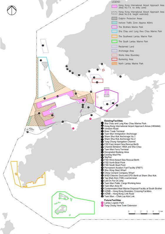
Figure 5-1a: Existing
and Future Marine Facilities and Dolphin Protection Areas Before Interim Two
Runway System (I-2RS)
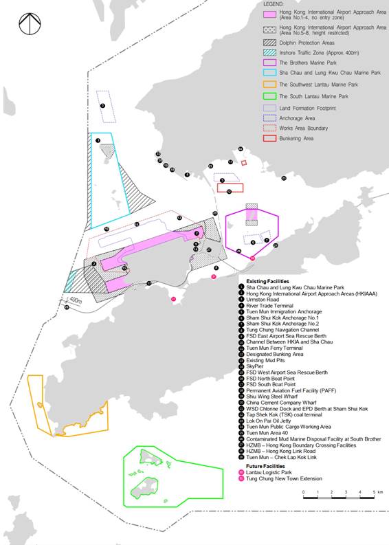
Figure 5-1b: Existing and Future Marine
Facilities and Dolphin Protection Areas After I-2RS and Before the Designation
of NLMP

Figure 5-1c: Existing and Future Marine Facilities
and Dolphin Protection Areas After the Designation of NLMP
5.2
Design of Marine Travel Route for Construction Vessels
5.2.1
General Arrangements for Construction Vessels
The marine travel route for
construction vessels was proposed based on best available information.
Nevertheless, the use of marine travel routes by construction vessels inside
and outside the Works Area would be monitored by the proposed on-shore control
room (it will be operated for 24 hours if night time works are required) with
the use of tracking system to be installed on all construction and associated
vessels (details to be discussed in Section 8.1 of this Updated Plan).
In addition, the Contractors would prepare rolling vessel plans for the
effective management of the numbers and the movements of the construction
vessels. The risk of any marine accidents within the Works Area would be
minimised with these measures.
Most of the non-self-propelled
vessels expected to be deployed during the construction works are barges
associated with ground improvement works (Section 2.4.1) and seawall
construction. Most of these vessels and associated tug boats will enter the
Works Area during mobilization periods before commencement of the relevant
phases of the construction works. They will then stay and work within the Works
Area. The associated tug boats will be required to use the predefined and
regular routes to manoeuvre all non-self-propelled vessels when they travel
outside the Works Area.
Self-propelled vessels (Section
2.4.2) and vessels delivering materials to and from the project site (Section
2.4.3) shall be required to use predefined and regular routes to reduce
disturbance to cetaceans due to vessel movements. Specific marine travel routes
covering waters outside the Works Area, designed based on the key factors
mentioned in Section 5.1.1 to Section 5.1.4, are shown in Figures 5-2, 5-3, 5-4a and 5-4b. The indicative
marine travel routes of construction vessels for delivery of fill materials
have been implemented since the commencement of reclamation, from which time
the number of construction vessels were kept to a practical minimum.
Restrictions on marine travel routes were not applicable to vessels working on
HDD pipeline and CLP cable laying, and ground investigation. HDD works involved
drilling activity well below the seabed in the bedrock level and only
positioning barge was temporarily mobilized (few hours a day) to assist the
detection of HDD pipeline alignment. In addition, floating platform was
set up just off the Sha Chau Island to support the HDD daylighting and
pipelines connection works on land. For the cable laying works, the route of
the water jetting barge followed the replacement cable alignment (See Appendix A) and works was done at a slow speed along the
alignment. As a high volume of construction vessel traffic was not anticipated
for these works, no additional restrictions were defined for this marine work
effort.
5.2.2
Construction Vessels Transit Route
The guiding principle for the
development of barge transit routes was to route barges into water-spaces where
they would have the least impact on existing marine traffic during the
construction period. Areas of particularly busy marine traffic include the
navigable waters and channels within the Western Harbour, around Tsing Yi and
up through Ma Wan and the Urmston Road area. Urmston Road is a busy operational
channel used by broad ranging vessel types including OGV. To avoid interfacing
with the existing marine traffic in the aforesaid areas of concern, the bulk of
barging volume associated with this project will be directed to arrive at the
works site principally from the west and east of the Works Area. This includes
those barges entering Hong Kong Waters from the north, which have been routed
south of the SCLKCMP. Construction marine traffic is to be minimised through
the Urmston Road as far as practicable.
As illustrated in Figures 5-2, 5-3, 5-4a
and 5-4b, the only transits which have been routed
through Hong Kong’s busiest waters are those public fill barges (i.e. pelican
barges and flat-top barges) to and from Tseung Kwan O/Tuen Mun and marine fill
barges (i.e. hopper barges and pelican barges) to and from the South China Sea
during the peak period. For the public fill barges, diverting them south of
Lantau to access the Works Area from the west would increase the transit time
by over 50%, therefore this traffic volume is accepted to travel through the Western
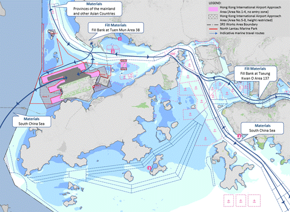
Harbour and Ma Wan areas. As the construction materials and fills may be
shipped from the Pearl River Delta, South China Sea, remote provinces of the
mainland and other Asian Countries by barge, construction vessels are routed to
enter the Works Area through designated site entrances on either side of the
land formation footprint primarily to minimise crossing traffic within the
narrowed channel north of the HKIA (Figures 5-2, 5-3, 5-4a and 5-4b).
The construction materials and
fills imported from locations outside Hong Kong may be transported to Hong Kong
using OGVs. These OGVs will anchor at suitable anchorage areas for
transshipment of the materials from the OGVs to feeder vessels (e.g. pelican
barges, derrick lighters) before transport to the Works Area. During peak
period, it will be necessary to maximise the use of all suitable gazetted
anchorage areas in the waters around the Lantau Island including Sham Shui Kok
Anchorage No. 2 (SSKA 2) within the BMP. Using SSKA 2 for transshipment
operations would only be considered after other suitable gazetted anchorage
areas were exhausted. AAHK has expressed to Marine Department that the use of
SSKA 2 would only be the last resort when other suitable gazetted anchorages
were not available or unfavourable for transhipment operations through the
monthly Marine Management Liaison Group (MMLG) meeting. Environmental Team (ET)
will keep the minutes of the MMLG meeting for record. When transshipment operation
is to be carried out in SSKA 2, the Contractor is required to implement
additional precautionary measures. These include 10-knot speed limit for
all feeder vessels within the BMP; avoidance of anchoring (except for emergency
purposes) for feeder vessels; using the shortest marine route for
entering/leaving the BMP (Figures 6-1a, 6-1b, 6-1c and 6-1d);
mooring close to the bulk carrier to minimize the gap in between vessels; using
closed grab to transfer sand and maintain at a low position for release of sand
for OGVs without conveyor; in-situ water quality monitoring; and implementation
of Dolphin Exclusion Zone during the transshipment operation. Details on
the implementation of these additional precautionary measures will be prepared
by the Contractor for review and approval by the ET, Independent Environmental
Checker (IEC) and AAHK prior to any transshipment operation at SSKA 2. In
addition to the EM&A programme, the ET will also carry out ad-hoc
environmental inspections of the transshipment operation within SSKA 2.
5.2.3
General Arrangements for Existing and Future Marine
Facilities
Construction vessel routes have
mostly avoided the existing and future marine facilities shown in Figures 5-1a, 5-1b and 5-1c. They have also avoided the existing Marine Parks
(i.e. the SCLKCMP, the BMP (except during transshipment operation), SWLMP and
SLMP) as well as the Dolphin Protection Areas at the construction stage. After
the NLMP is designated, the construction and associated vessels have to pass
through the NLMP when coming / leaving the Works Area. The construction and
associated vessels shall minimize their travelling route within the NLMP and
adhere to at a 10-knot speed limit (AFCD, n.d.) when passing through the NLMP.
The route along Urmston Road passes close to the SCLKCMP and this area is a key
CWD habitat (Hung, 2015) and a 10-knot speed restriction shall also be applied
in regions with high CWD abundance, as determined by referring to a Dolphin
Habitat Index that has been established for waters in this area (see Section
7.3 for details). The marine travel route shall not be changed once
approved. Reasonable justifications shall be provided if any changes of the
proposed routes are required.
The Pilotage Advisory Committee
Paper No. 4/2016 recommended that an inshore traffic zone of about 300m to 400m
in width shall be maintained between the boundary of the proposed Marine Parks
(SLMP and Soko Islands Marine Park) and the nearby Lantau Channel Traffic
Separation Scheme (LCTSS) / Traffic Separation Scheme at South of Lantau
(SLTSS) to allow an unrestricted and safe channel for navigation and to
minimize potential impacts to marine users. Taking into consideration marine
safety, an inshore traffic zone of about 400m in width is proposed between the
Hong Kong water boundary and the western part of the Dolphin Protection Areas
to allow the 3RS construction vessels coming / leaving from the southwest to
the Works Area. The construction vessels passing through this inshore traffic
zone shall be kept not more than 10 knots.
It was noted that existing
submarine aviation fuel pipelines were diverted as part of this Project by
using HDD method to drill through bedrock from a launching site located at the
west of the airport island to a daylighting point on Sheung Sha Chau Island.
Construction and associated vessels had to enter the SCLKCMP. As good practice,
the construction vessels travelling to and from the work site within the
SCLKCMP was minimised their travelling route within the Marine Park as well as
adhering to the 10-knot speed limit applicable inside the Marine Park.
5.2.4
Guidelines for Safe Vessel Operations Travelling Outside and
Within the Works Area
Apart from transportation boats
and those vessels involved in materials delivery, many of the working vessels
(e.g. crane barges, derrick barges, tug boats, DCM & PVD barges, spreader
pontoons, etc.) will mostly stay within the Works Area. Guidelines for safe
vessel operations in the presence of CWDs (Section 6.3), including
keeping to 10-knot speed limit within the Works Area, will be implemented to
minimise any disturbance from such vessels to CWDs.
Vessel skippers / captains shall
strictly follow all navigation safety requirements and international practices
with the help of navigation instruments. Marker buoys and navigation buoys will
be used as marine based indicators to help the vessel skippers / captains in
locating the proper traffic routes under actual situations and during any
unexpected incidents. Marine travel routes may be attuned locally for safety
reasons, taking into account other marine vessels that may be encountered by
construction and associated vessels. The navigation routes may also be affected
by natural factors including wind, currents, waves, poor visibility and
periodic closure of certain routes (e.g. due to other unusual events). A key
commitment is that there shall be no transportation of oversize materials or
easily spillable materials such as marine fill during inclement weather.
Construction and associated
vessels will not enter the Dolphin Protection Areas as shown in Figures 5-1a, 5-1b and 5-1c under normal circumstances. The Dolphin
Protection Areas have been implemented during the construction phase, within
which there will be effective management controls on construction vessels of
the 3RS project.
After the NLMP is designated,
there are three areas as shown in Figure 6-1c,
which are within the works area boundary and are not included in the NLMP
namely Area A (located at the western side of the newly reclaimed land between
the centre runway and the third runway); Area B (located at the eastern side of
newly reclaimed land between the centre runway and the third runway) and Area C
(located at Fire Services Department West Airport Sea Rescue Berth). When the
construction and associated vessels travel through these three areas outside
the marine park, the requirements of Marine Parks Ordinance do not apply.
Within the Works Area, it is
expected that different marine travel routes will be required for accessing
different Works Area from various piers for each construction contracts.
Material trucks/vehicles will use available piers or landing points offsite e.g.
Tuen Mun Public Cargo Working Area, Tuen Mun Area 40 and River Trade Terminal
etc. for accessing the Works Area by roro barges from time to time. In
order to reduce disturbance to cetaceans due to vessel movements, construction
vessel shall adhere to the following principles for the general routes for
construction vessels travelling within the Works Area:
● All construction and associated vessels
shall only access the Works Area through the west gate or east gate;
● All construction and associated vessels
shall follow the routes with practicable minimum distance from the entrance of
the Works Area to the designated works site;
● Main routes shall be used after
entering the Works Area. Branches routes shall be minimised as far as
practicable;
● Sudden course changes shall be
avoided to reduce disturbance to cetaceans; and
● All vessels shall adhere to the
speed limit of 10-knot or below within Works Area.
Vessel skippers / captains will be informed of the above principles for the general routes for construction vessels within the Works Area during the Skipper Training Workshops.
Figure 5-2: Indicative
Marine Travel Route with Forecast Construction Traffic Movements during Peak
Period per Day After Commencement of Reclamation Before I-2RS (modified from
BMT, 2014)
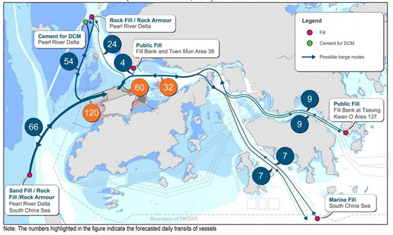
Figure 5-3: Indicative Marine Travel Route with Forecast
Construction Traffic Movements on Average per Day After Commencement of
Reclamation Before I-2RS (modified from BMT, 2014)
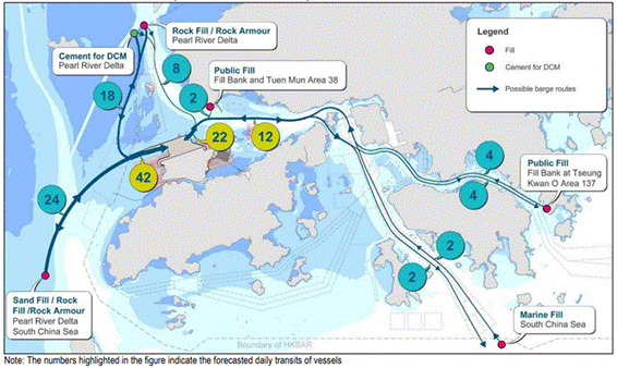
Figure 5-4a: Indicative Marine Travel Route After I-2RS
and Before the Designation of NLMP

Figure 5-4b: Indicative Marine Travel Route After the
Designation of NLMP
5.2.5
Contingency Arrangements
Contingency plans have been developed
for periods of disruption, such as typhoons, strong monsoon signals,
thunderstorms, black rain alerts, and accident incidents upon commencement of
land formation works. Respective plans will need to be developed by relevant
parties, but those operating construction and associated vessels may be
expected to adhere to the general principles outlined below.
The typhoon arrangements will
require all work barges/craft to leave the Works Area on or before Typhoon
Signal no. 3 is hoisted.
It is anticipated that the main
designated typhoon shelters for works vessels will be the Tuen Mun Typhoon
Shelter and the Hei Ling Chau Typhoon Shelter. Tug & tow / crane barge will
leave from the Works Area and travel via Ma Wan Fairway to the Hei Ling Chau
Typhoon Shelters on or before the Typhoon Signal 3 is raised. However, due to
the large numbers of works vessels involved in the construction of the
reclamation, it is possible that typhoon shelters within Hong Kong waters will
not be able to cater for this level of demand. Works vessels will also have to
shelter within deep water space within Mainland China providing the nearest
sheltered site.
Procedures have been developed by
all marine works Contractors to allow for a phased departure of works craft
from the site in the event of a typhoon, so that navigation channels do not
become overcrowded and to avoid obstructing the passage of other vessels on or
before the Typhoon Signal no. 3 is hoisted. Figure 5-5
presents potential routes to be taken by works vessels during typhoons.
For example:
● Deep
draught / high airdraft vessels shall be first to leave the site when the
Typhoon Signal no. 3 is anticipated to be hoisted by the Hong Kong Observatory
within 2-4 hours.
● Tug
& Tow vessels shall then leave the site after these deep draft vessels have
left.
● Smaller,
more manoeuvrable support vessels shall then leave the site when the Typhoon
Signal no. 3 is hoisted.
In case of marine accidents (e.g.
collision, grounding, search and rescue including aeronautical incident) that
may occur during the construction stage, actions will be required to manage
vessels during these events and re-routing, control and regulation of marine
traffic may be required. It is anticipated that this response will be
similar in manner to the response to such incidences elsewhere within Hong Kong
waters. The precautionary / mitigation measures of potential oil spill can be
referred to in the Spill Response Plan (SRP) which provides the guidelines for
setup of contract-specific SRPs by Contractors.
Further to Fire Services Department’s comment, emergency access points shall be allowed from the north side to the Works Area. These access points are only allowed for marine police and fire boat for marine rescue purposes only.
Figure 5-5: Potential Routes to Typhoon Shelters

6
Skipper Training and Guidelines for
Safe Vessel Operations in the Presence of the CWDs
6.1
Impacts on CWDs and Precautionary Measures
As assessed in the approved EIA
report, construction vessels will be largely slow-moving, however the
activities they will be undertaking may cause physical disturbance and can
cause noise disturbance to CWDs. Noise from the slow moving vessels themselves
is not expected to have a serious impact on CWD behavior and was considered of
low impact significance in the EIA. Also, the risk of construction vessel
collisions with CWDs was also considered to represent a low impact significance
in the EIA.
Even so, skipper training and
vessel controls have been recommended as precautionary measures in the approved
EIA report to further minimize any potential impacts. A speed limit of 10-knot
shall be strictly observed for construction vessels within the areas with high
CWD density.
6.2
Skipper Training
The ET shall provide training to
vessel skippers / captains to ensure vessel operations pose minimal risks to
CWDs. The training shall include briefings on predefined routes, general
education on local cetaceans, guidelines for avoiding adverse water quality
impact, the required environmental practices / measures while operating
construction and associated vessels under the Project, and guidelines for
operating vessels safely in the presence of CWDs (Section 6.3). The ET
shall schedule the training with individual Contractors and ensure all marine
vessel skippers / captains working on the Project are adequately briefed and
trained prior to marine construction or prior to skippers / captains commencing
work operating vessels in Works Area. The overall principles for construction
vessels travel within / outside the Works Area are shown in Figures 6-1a, 6-1b, 6-1c and 6-1d. The no entry
zones which defined as Marine Parks, Dolphin Protection Areas, and 10-knot
speed limit areas within / outside the Works Area are shown in Figure 6-1d. The training materials will be prepared
by ET and endorsed by the CWD specialist, and all material used shall be
updated time to time during the construction of the project. The ET will
conduct the training and refresher courses as and when required (e.g. in the
event that the regular travel route is updated along as work progresses), to
ensure that the vessels shall be used in a dolphin-friendly manner. The vessel
skippers / captains training record will be reported in the Monthly EM&A
Report. All relevant training records and training materials shall be kept by
the ET and made available to IEC, AAHK and EPD upon request.
6.3
Guidelines for Safe Vessel Operations in the Presence of the
CWDs
One of the major human-caused
threats to CWDs is injury / death due to marine vessel collision. Locations
with frequent CWD sightings near the proposed vessel routes shall be passed
with more caution to avoid impact on CWDs. Reference may be made to the “Code
of Conduct for Dolphin Watching Activities” published by Agriculture, Fisheries
and Conservation Department (AFCD) and other relevant sources. A code of
conduct for construction and associated vessels in the presence of CWDs is
provided in Appendix C. The following measures are
also considered to be helpful to minimise the chance of a vessel striking CWDs
and will be covered in training sessions:
● All
vessels will enter the Works Area through designated site entrances, as shown
in Figures 6-1a, 6-1b,
6-1c and 6-1d;
● All
vessels will travel at a speed no greater than 10 knots in the Works Area,
which will be demarcated by floating booms and yellow marker buoys;
● The
vessel captain shall always remain a vigilant for the presence of CWDs and make
sure they slow down prior to passing known CWD hotspots, and take actions to
avoid disturbance to or collisions with CWDs;
● The
construction and associated vessels shall strictly observe a speed limit of
10-knot within CWD hotspot areas (also known as ‘highly critical’ dolphin
habitats’ in Figures 7-5a, 7-5b
and 7-5c);
● Construction
and associated vessels shall avoid passing through existing Marine Parks
(including the SCLKCMP, the BMP, SWLMP and SLMP), except for the case of the
SCLKCMP in association with works on the diversion of aviation fuel pipeline
and the temporary works such as setting up the generator at the Sha Chau,
Sheung Sha Chau and Lung Kwu Chau for the cable diversion work and during
transshipment operation at SSKA 2;
● Construction
and associated vessels shall not anchor or stopover within the existing Marine
Parks (including the SCLKCMP, the BMP, SWLMP, SLMP), except for the case of the
SCLKCMP in association with works on the diversion of aviation fuel pipeline
with AFCD’s authorization and the temporary works such as setting up the
generator at the Sha Chau, Sheung Sha Chau and Lung Kwu Chau for the cable
diversion work and during transshipment operation at SSKA 2;
● After
the designation of NLMP, the construction and associated vessels have to pass
through the NLMP when coming / leaving the Works Area. The construction and
associated vessels shall minimize their travelling route within the NLMP,
adhere to at a 10-knot speed limit (AFCD, n.d) when passing through the NLMP
and not anchor / stopover within the NLMP; and
● Construction
and associated vessels shall not enter the Dolphin Protection Areas (see Figures 5-1a, 5-1b and 5-1c) under normal circumstances.
Figure 6-1a: Overall Principles for Construction
Vessels Travel Within / Outside the Works Area Before I-2RS

Figure 6-1b: Overall Principles for Construction
Vessels Travel Within / Outside the Works Area After I-2RS and Before the
Designation of NLMP
Figure 6-1c: Overall Principles for Construction
Vessels Travel Within / Outside the Works Area After the Designation of NLMP

Figure 6-1d: No Entry Zone and 10-knot Speed Limit Area
for Construction Vessels Travel Within / Outside the Works Area After the
Designation of NLMP
7
Speed Limit of 10-knot for
Construction Vessels within Works Area & CWD Hotspots
7.1
Works Area
Apart from transportation boats
and those vessels involved in materials delivery, many of the working vessels
(e.g. crane barges, derrick barges, tug boats, DCM & PVD barges, spreader
pontoons, etc.) will mostly stay within the Works Area. However, all
construction and associated vessels shall adhere to the speed limit of 10-knot
or below within Works Area as shown in Figures 6-1a,
6-1b, 6-1c and 6-1d to minimise any disturbance from such vessels to
CWDs.
7.2
Dolphin Protection Areas
According to the approved EIA
report, construction vessel impacts were evaluated as of low impact
significance to CWDs. However, mitigation measures including speed limits of
10-knot in CWD hotspots (this section) and skipper trainings (refer to Section
6.2) are recommended as precautionary measures. Speed limit of 10-knot for
construction vessels appears to be effective in protecting CWDs from vessel
collisions and acoustic disturbance. In addition, the Dolphin Protection Areas
(see Figures 7-5a, 7-5b and 7-5c) have been proposed during the construction phase
in response to ACE comments during the EIA approval process, within which there
will be effective management controls on construction vessels of the 3RS
project. In order to avoid disturbance to the Marine Parks, proposed routes of
construction vessels have been designed to avoid construction and associated
vessels travelling across existing Marine Parks (i.e. the SCLKCMP, the BMP
(except during transshipment operation), SWLMP and SLMP). Also, after the NLMP
designation, the construction and associated vessels have to pass through the
NLMP when coming / leaving the Works Area. The construction and associated
vessels shall minimize their travelling route within the NLMP, adhere to at a
10-knot speed limit (AFCD, n.d.) when passing through the NLMP and not anchor or stopover within the
NLMP.
7.3
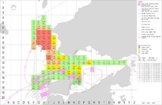
Chinese White Dolphin “Hotspot” Areas
As discussed in Section 5.2, the
proposed marine travel routes for construction vessels have mostly avoided
the proposed SLMP in the western waters as well as the Dolphin Protection Areas. The proposed
marine travel routes have also avoided the Dolphin Protection Areas (see Figures 7-5a, 7-5b and 7-5c) proposed by AAHK in response to ACE comments
during the EIA approval process. However, given that the route along Urmston
Road to the northeast of SCLKCMP is a CWD key habitat, a 10-knot speed
restriction will be imposed on the construction and associated vessels passing
areas with high CWD abundance (i.e. ‘highly critical’ dolphin habitats in Figures 7-5a, 7-5b and 7-5c).
In order to determine the area to which speed
limits of construction and associated vessels shall be applied for reducing
impacts on CWDs, data from the AFCD long-term surveys (see Hung 2014 for a
description of these data) have been evaluated to make the best possible
determination of the relative value of each 1 x 1 km grid for use in this
exercise. The latest available data including the recent marine mammal
monitoring report (Hung, 2023) has been taken into account for developing the
dolphin habitat index.
It was decided that, in order to avoid
potential biases from any single measure, a matrix of four measures of dolphin
use of each grid would be used. For each 1 x 1 km grid in the potential HSF
route area, four factors have been considered:
1. Current density by DPSE, i.e. the
number of CWDs per 100 units of survey effort in the 1 x 1 km grid (Figure 7-1; from Hung, 2023)
2. Historical density by DPSE (Figure 7-2; from Hung, 2014)
3. Habitat rating (Figure
7-3; from Hung, 2014)
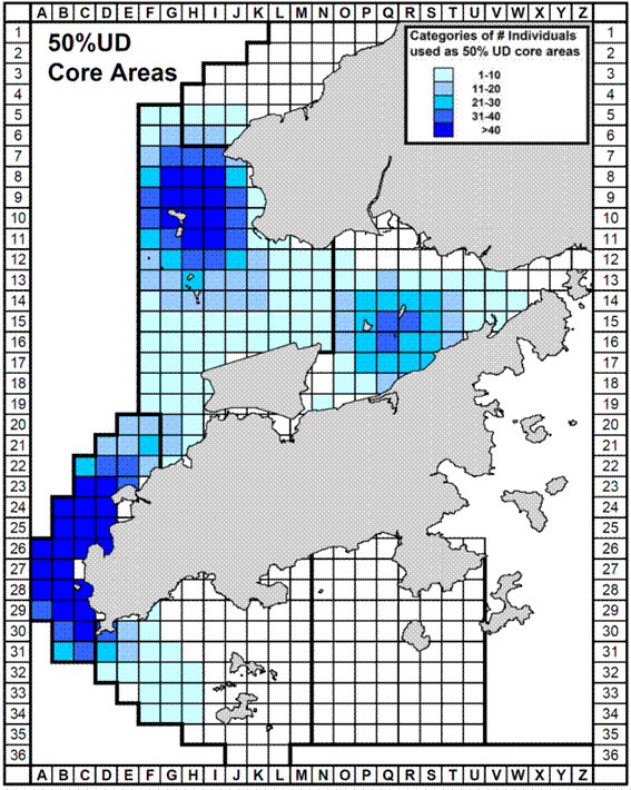
4. 50% core area usage by CWDs (Figure 7-4; from Hung, 2014)
All of these four factors are based on dolphin
numbers per unit effort, but including data on the four factors helps to ensure
the analysis has broad temporal and biological relevance, and minimizes impacts
of potential data anomalies from using just a single factor. A matrix of the
relevant data was compiled. For each 1 x 1 km grid, there are four values
presented, corresponding to the four factors listed above, and for each one
evaluated as “Low”, “Medium” or “High” (note that these are subjective descriptive
terms, though objective quantitative values for building the matrix were used).
For densities (both current and historical), the corresponding values for “Low”
were 0.0-20.0, 20.1-40.0 for “Medium”, and 40.1 or above for “High”. For
habitat ratings, the corresponding values for “Low” were 0-10, 11-20 for
“Medium”, and 21 or above for “High”. For 50% core areas, the
corresponding values for “Low” were 0-10, 11-30 for “Medium”, and 31 or above
for “High”. Relevant raw data are presented in detail in Hung (2014) and Hung
(2023). The dolphin habitat index is then developed for each grid as shown in Figures 7-5a, 7-5b and 7-5c.
Table 7-1: Criteria for
each 1 km2 grid in defining the dolphin habitat index, based on the
ranking of four factors (i.e. current density by DPSE, historical density by
DPSE, habitat rating and 50% core area usage by CWDs)
|
Dolphin habitat index |
Criteria |
|
Least Critical |
·
3
“Low”; or ·
4
“Low” |
|
Less Critical |
·
2
“Medium” and 2 “Low”; or ·
1
“High” and 1 “Medium and ” 2 “Low” |
|
Moderately Critical |
·
2
“High” and 1 “Medium”; or ·
2
“High” and 2 “Low”; or ·
1
“High” and 2 “Medium”; or ·
3
“Medium” |
|
Highly Critical |
·
3
“High”; or ·
4
“High” |
The resulting matrix (see Figures
7-5a, 7-5b and 7-5c)
identifies highly critical areas of CWD habitat to the northeast of SCLKCMP
which are delineated by boundary points A – J with GPS coordinates. Speed
limits within these areas will be limited to 10 knots or less and this will be
communicated to construction vessel skippers / captains during the skipper
trainings. However, there may be exceptional cases that the 10-knot speed limit
could be relaxed for contingency arrangements (e.g. during typhoon, adverse
weather conditions) and for safety or emergency purposes.
The CWD “Hotspot” areas will be reviewed
annually based on the AFCD Marine Mammal Monitoring Report.
Figure 7-1: Current density
of Chinese White Dolphins with corrected survey effort per km2 in
waters around Lantau Island between January – December 2022 (number within
grids represent “DPSE” = no. of dolphins per 100 units of survey effort; from
Hung, 2023). In the dolphin habitat index developed for this plan, DPSE of 0.0
– 20.0 is rated as “Low”, 20.1 – 40.0 as “Medium” and 40.1 or above as “High”.
Figure 7-2: Historical
density of Chinese White Dolphins with correct survey effort per km2
in waters around Lantau Island during 2001 – 2012 (numbers within grids
represent “DPSE” = no. of dolphins per 100 units of survey effort; from Hung,
2014). In the dolphin habitat index developed for this plan, DPSE of 0.0 – 20.0
is rated as “Low”, 20.1 – 40.0 as “Medium” and 40.1 or above as “High”
Figure 7-3: Habitat rating
of Chinese White Dolphins in Hong Kong using quantitative habitat use information
collected during 2001 – 2012 (number with grids represents the sum of scores
totalled from 10 selection criteria; from Hung, 2014). In the dolphin habitat
index developed for this plan, habitat rating of 0 – 10 is rated as “Low”, 11 –
20 as “Medium”, and 21 or above as “High”
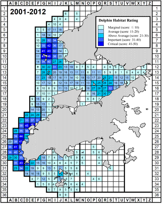
Figure 7-4: Number of
individual Chinese White Dolphins with their 50% utilization distribution (UD)
core areas overlapped with each 1 km2 grid in waters around Lantau
Island from 2001 – 2012 (Hung, 2014). In the dolphin habitat index developed
for this plan, 50% core area of 0-10 is rated as “Low”, 11-30 as “Medium”, and
31 or above as “High”
Figure
7-5a: Dolphin Habitat Index and Marine Travel Routes Before I-2RS
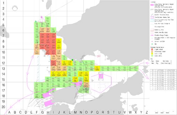
Figure
7-5b: Dolphin Habitat Index and Marine Travel Routes After I-2RS and Before the
Designation of NLMP
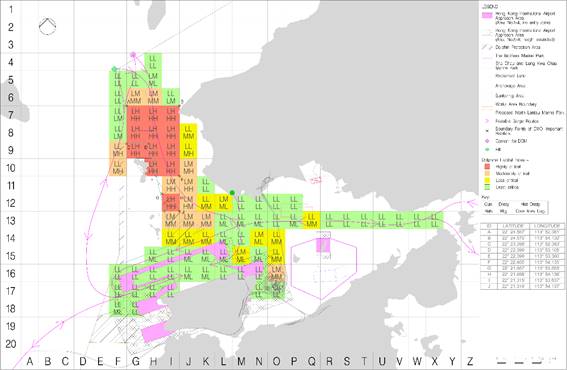
Figure
7-5c: Dolphin Habitat Index and Marine Travel Routes After the Designation of
NLMP
8
Implementation and Monitoring
8.1
Method of Implementation and Monitoring before the
Commissioning of Three-runway System
8.1.1
Marine Traffic Monitoring Systems
Construction vessel routes for
land formation works have been developed to keep the majority of transits out
of Urmston Road and other key channels within Hong Kong Waters. It is
recommended that construction vessels access the works site via the west and
east site entrances to avoid using the busy channel north of the Works
Area.
To monitor and manage 3RS vessel
activities, a Marine Traffic Monitoring System (Figure
8-1) has been established to ensure that works vessels:
● Travel
to/from the Works Area via designated transit routes;
● Access/depart
works site via designated site entrances;
● Obey
speed limits and any other navigation controls that are prescribed;
● Avoid
passing through existing Marine Parks (including the SCLKCMP, BMP, SWLMP and
SLMP);
● Neither
anchor nor stopover within the existing Marine Parks (including the SCLKCMP,
BMP, SWLMP and SLMP) without authorization; and
● After
the designation of NLMP, the construction and associated vessels have to pass
through the NLMP when coming / leaving the Works Area. The construction and
associated vessels shall minimize their travelling route within the NLMP,
adhere to at a 10-knot speed limit (AFCD, n.d.) when passing through the NLMP
and not anchor or stopover
within the NLMP.
Key elements of the Marine
Traffic Monitoring System will include:
● A
requirement for a tracking system (e.g. Automatic Identification System (AIS)
Transponders) to be installed on all construction and associated vessels;
● An
on-shore control room (with 24-hour operation if night time works is required)
to monitor, manage and communicate via Very High Frequency (VHF) or mobile
phone and other practical communication system with construction vessels; and
● A
clearly defined set of warnings for non-compliance with prescribed navigation
controls.
Vessels which deliver materials including for
example sandfill, rockfill and prefabricated units are expected to pass through
the Urmston Road Fairway and some CWD hotspots. If temporary material delivery
vessels that have not been registered with AIS will require a guard boat with
AIS installed to lead the way within the Works Area until the vessels station
within the Works Area, otherwise, the vessels will not be allowed to enter the
Works Area. In order to keep the construction-related vessels to a
practical minimum, the site
staff transportation vessel could be act as the guard boat during the
transitional period. The Contractors shall ensure that the material
delivery schedule is arranged where the site staff transportation vessel is
able to lead the temporary material delivery vessel to the designated
construction Works Area. A
tight control on the marine travel routes will be implemented to minimise
traveling routes within CWD hotspots.
Site investigation (S.I.) vessels which mainly
deployed for preparing the construction works and stationary at specific S.I.
monitoring locations at most of the time, are not classified as construction
and associated vessels. However, S.I. vessels will also travel to/from the
Works Area via designated transit routes and access / depart works site via
designated site entrances with speed limit same as other construction vessels.
For this kind of S.I. vessel which may not equipped with an AIS tracking system,
the Contractors shall provide alternative tracking records (e.g.
global positioning system (GPS) log) to the on-shore control room for auditing.
The tracking records shall include the time, date, coordinates, travelling
route and travelling speed.
For the newly awarded Contractors onboard, ET
will work with the Contractors to review and get familiarised with the
requirements of this Updated Plan in the first month including predefined and
regular routes for construction vessels covering waters both within and outside
the Works Area, speed control within the Works Area, CWDs hotspot areas and
Dolphin Protection Areas, as well as providing skipper training to the skippers
/ captains.
8.1.2
Record of Travel Route
Tracking systems (e.g. AIS) will
be used in all construction and associated vessels to record use of the marine
travel routes for track logging.
All daily records of marine
travel routes used (including details, times, dates and purpose of journeys)
will be maintained by the supervising staff. The records shall be submitted for
inspection by Contractors upon request. The skippers / captains of construction
vessels and their companies or material suppliers will receive formal warning
notice if records show the approved marine travel route was not followed.
During the construction phase the
ET will be required to audit the implementation of the requirements detailed in
this Updated Plan (e.g. marine travel routes to / from the Works Area, speed
etc.). Travel route logs, including coordinate points logging of individual
tracks and graphical plots of all vessel tracks overlaid on the base map of
Hong Kong, shall be provided to the ET, IEC and AAHK at regular intervals after
commencement of the marine construction works.
8.1.3
Water Quality and Vessel Movement
During water quality monitoring,
observations of the surrounding activities were recorded. Should exceedance of
water quality be recorded, inspection was carried out including checking of the
observation log, the AIS data showing the construction traffic route and volume
of construction traffic at the time of exceedance. The available records on
number of construction vessels within the work site were also reviewed. Actions
were taken if exceedance of water quality was recorded according to the Event
and Action Plan recommended for the water quality monitoring as presented in
the EM&A Manual. In particular, the ET discussed required mitigation
measures with the Contractors, IEC, and AAHK/PM. In the event that frequent
water quality Action or Limit Level exceedances happened without apparent
reasons, efforts were made to analyze if such exceedances are attributable to
the number of construction vessels in the works site for consideration of
possible remediation actions, such as limiting the number / movement /
anchoring or de-anchoring of construction and associated vessels on site.
All construction and associated
vessels shall comply with the relevant international conventions, and local
regulations and requirements of the Marine Department where applicable,
including:
● The
Shipping and Port Control Ordinance (Cap. 313);
● The
Shipping and Port Control Regulations (Cap. 313A);
● The
Merchant Shipping (Miscellaneous Craft) Regulations (Cap. 313F);
● The
Merchant Shipping (Safety) Regulations (Cap. 369);
● The
Merchant Shipping (Safety) (Signals of Distress and Prevention of Collisions)
Regulations (Cap. 369N);
● The
Dangerous Goods Ordinance (Cap. 295);
● The
Dangerous Goods (Shipping) Regulations (Cap. 295C);
● The
Merchant Shipping (Launches and Ferry Vessels) Regulations (Cap. 313E);
● The
Merchant Shipping Ordinance and Regulations (Cap. 281);
● The
Merchant Shipping (Local Vessels) Ordinances (Cap. 548);
● The
Shipping and Port Control (Works) Ordinance (Cap. 313X); and
● The
International Regulations for Preventing Collisions at Sea 1972.
Figure
8-1: Typical Marine Traffic Monitoring System
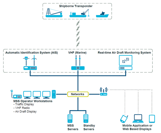
8.1.4
Supervision Staff
Implementation would be enforced
by AAHK and implemented by the Contractors and will apply to all vessels
engaging in construction works under 3RS contract agreements. However, AAHK has
ultimate responsibility for overseeing marine traffic control measures as
described in Section 8.1. Construction related marine vessel traffic
management including the implementation of all of the precautionary and
mitigation measures as approved by the Statutory Authority will be coordinated
by the AAHK established Marine Traffic Monitoring System / on-shore control
room using suitable AAHK or specialist consultant staff along with Contractors
if necessary. The ET will monitor and audit the implementation and
effectiveness of the precautionary and mitigation measures as stipulated in
this Updated Plan upon the completion of construction phase of the project.
8.2
Method of Implementation and Monitoring after the
Commissioning of Three-runway System
Following the completion of land
formation works including seawall construction and all marine filling works in
the first quarter of 2023 with the commencement of land access transportation
services to / from the newly reclaimed land from early 2023 and the
commissioning of 3RS on 28 November 2024, the number of construction and
associated vessels has significantly declined. In addition, the
construction phase impact water quality monitoring and the construction phase
impact CWD monitoring were terminated after October and December 2023,
respectively. There has been a notable decline in the number of
construction and associated vessels and scheduled ferry services. The daily
trips of the construction and associated vessels have dropped by approximately
80% when compared with the peak period. Currently, scheduled ferry
services are the primary vessels travelling to and from the newly reclaimed
land, while construction and associated vessels are infrequent. It is expected
the number of trips of the construction and associated vessels and scheduled
ferry services will continuously decrease towards the end of the construction
period. In view of this, the marine traffic monitoring requirements and
procedures have been updated accordingly.
8.2.1
Updated Marine Traffic Monitoring Requirements
To monitor and manage the
remaining 3RS vessel activities, the requirements have been updated as follows
to suit the current site conditions and the newly designated NLMP.
● The
construction and associated vessels shall travel to / from the newly reclaimed
land / designated loading and unloading points via designated transit
routes;
● The
construction and associated vessels shall obey speed limits and any other
navigation controls that are prescribed;
● The
construction and associated vessels shall avoid passing through Marine Parks
including the SCLKCMP, BMP, SWLMP and SLMP except NLMP;
● The
construction and associated vessels shall minimize their travelling route
within the NLMP and adhere to the 10-knot speed limit when the vessels have to
pass through the NLMP to access to the site; and
● The
construction and associated vessels shall not anchor or stopover within the
Marine Parks (including the SCLKCMP, BMP, SWLMP, SLMP and NLMP) without
authorization.
The Contractors should comply
with all the relevant requirements stipulated in this Updated Plan, including
but not limited to the following:
● A
requirement for a tracking system (e.g. Automatic Identification System (AIS)
Transponders) to be installed on all construction and associated vessels;
● The Contractors to prepare a monthly
construction vessel activities programme to report the actual construction
vessels deployed and marine movements together with the planned vessel
movements on a 3-month rolling basis to AAHK/PM;
● The
Contractors to monitor and communicate (i.e. via mobile phone and other
practical communication system) with construction and associated vessels
skippers / captains. If any construction and associated vessels deviate from
the designated transit routes, violate the speed limits, anchor or stopover
within the Marine Parks, the Contractors shall remind the concerned skippers /
captains to follow the marine traffic monitoring requirements and provide
refresh training to the concerned skippers / captains if necessary; and
● The
Contractors are required to rectify the issues and provide immediate refresh
training to the concerned skippers/ captains upon receiving formal warning
notices from ET.
8.2.2
Marine Traffic
Monitoring and Audit Procedures
The monitoring and auditing procedures
are updated as follows:
● The
ET shall request the Contractors to submit the marine travel routes records for
monthly audit. The marine travel route records shall include times, dates,
purpose of journeys, marine travel routes and travelling speed. The ET will
determine the number of marine travel route records for audit based on the
number of construction and associated vessels traveling to/from the newly
reclaimed land each month, as indicated in the monthly construction vessel
activities program submitted by the Contractors;
● The
ET shall audit the marine travel routes record to ensure the Contractors
implement and comply with the requirements; and
● The
ET shall check the marine travel route separately on a monthly basis. If
it is indicated that vessels did not adhere to the requirements, the skippers /
captains of vessels and the concerned Contractors will receive warning notices.
The Contractors are required to rectify these issues and provide immediate
refresh training to the concerned skippers / captains.
8.2.3
Termination of the Updated Marine Traffic Monitoring and
Audit
After the designation of NLMP,
the newly reclaimed land is bounded by NLMP. All construction and
associated vessels travelling to and from the newly reclaimed land pass through
the NLMP after the commissioning of 3RS operation. These vessels are now
required to adhere to a 10-knot speed limit and are prohibited from mooring or
anchoring within the NLMP without authorization under the Marine Parks
Ordinance. Consequently, the effect of the mitigation measures imposed by
this Updated Plan is now largely covered by similar requirements for the NLMP
stipulated in the Marine Parks Ordinance, To ensure all skippers / captains are
familiar with the requirements of the newly designated NLMP, the ET will
continue to monitor the movements of construction and associated vessels.
Additionally, the ET will review the site conditions and the implementation
status of the Updated Plan. The ET should propose the termination of
monitoring which the proposal should be endorsed by the AAHK / PM and IEC, and
agreed by EPD.
9
Summary and Conclusion
This Updated Plan presents a
summary of major construction works and details of the types of vessels and
marine plant expected to be involved. Technical guidelines to avoid adverse
water quality impacts during vessel operations, as well as practices to keep
construction-related vessels and marine plant to a practical minimum have been
provided. The different factors considered in determining construction vessel
travel routes in the MTIA are summarized and both general and contingency
arrangements are provided in the design of the marine travel routes.
Specifications for skipper
training as well as guidelines for safe vessel operations in the presence of
CWD are covered in this Updated Plan. A 10-knot speed restriction is designated
within the Works Area, the NLMP (after designation) and in ‘highly critical’
dolphin habitats that have been determined by Dolphin Habitat Index making
reference to the AFCD monitoring reports of marine mammals in Hong Kong waters.
In addition, methods of implementing and monitoring the effectiveness of the
proposed mitigation and precautionary measures through the use of an AAHK
established and managed Marine Traffic Monitoring System / on-shore control
room are detailed. This facility will be managed by AAHK and overseen by
the ET to ensure compliance to this Updated Plan by all 3RS vessel operators.
The predefined and regular routes for construction vessels are subject to
further review during construction stages and this Updated Plan shall be
updated as necessary.
After the 3RS was commissioned on 28 November 2024, the monitoring and implementation requirements have been updated. The marine traffic monitoring will be terminated upon agreement with EPD.
10
References
Agriculture,
Fisheries and Conservation Department. (n.d.) Marine Parks Management.
Agriculture, Fisheries and Conservation Department for the Hong Kong SAR
Government. Available from
https://www.afcd.gov.hk/english/country/cou_vis/cou_vis_mar/cou_vis_mar_pla/cou_vis_mar_pla_mpmp.html
BMT. (2014). Marine Traffic Impact
Assessment for Hong Kong International Airport Contract P281 – Third Runway
Reclamation Design Consultancy Services – Scheme Design Report.
Hung, S. K. 2008. Habitat use
of Indo-Pacific humpback dolphins (Sousa chinensis) in Hong Kong. Ph.D.
dissertation. University of Hong Kong, Hong Kong, 266 p.
Hung, S. K. Y. (2014).
Monitoring of marine mammals in Hong Kong waters (2013-14): Final report (1
April 2013 to 31 March 2014). Submitted to the Agriculture, Fisheries and
Conservation Department of the Hong Kong SAR Government. Retrieved from http://www.afcd.gov.hk
Hung, S.K.Y. (2015) Monitoring
of marine mammals in Hong Kong waters (2014-15): Final report (1 April 2014
to 31 March 2015). Submitted to the Agriculture, Fisheries and Conservation
Department for the Hong Kong SAR Government. Available from http://www.afcd.gov.hk.
Hung, S.K.Y. (2023) Monitoring of marine mammals in Hong Kong waters (2022-23): Final report (1 April 2022 to 31 March 2023). Submitted to the Agriculture, Fisheries and Conservation Department for the Hong Kong SAR Government. Available from http://www.afcd.gov.hk.
Appendix
A Project Location
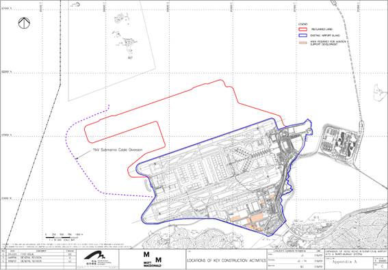
Appendix B Working Vessels Involved
in the Construction Activities
|
Vessel Type |
|
*Depth / Draft (m) |
|
Crane Barge/Derrick
Barge |
|
Depth: approx. 5.51 Draft: approx. 4.1 |
|
Trailing Suction
Hopper Dredger (TSHD) |
|
N.A. |
|
Spreader Pontoon |
|
N.A. |
|
DCM Barge |
|
Depth: approx. 3.50 Draft: approx. 1.50 |
|
Depth: approx. 4.5 Draft: approx. 2.5 |
||
|
Depth: approx. 5.0 Draft: approx. 3.0 |
||
|
PVD Barge |
|
Depth: approx. 4.30 Draft: approx. 3.0 |
|
Depth: approx. 3.20 Draft: approx. 2.0 |
||
|
Cement Barge |
|
N.A. |
|
Hopper Barge for
delivery of Public Fill |
|
Depth: approx. 5.50 Draft: approx. 4.1 |
|
Water Jetting Barge |
|
N.A. |
|
Flat-top Barge |
|
N.A. |
|
Pelican Barge |
|
N.A. |
|
Tug Boat |
|
N.A. |
|
Anchor Boat |
|
N.A. |
|
Transportation Boat
/ Ferry |
|
N.A. |
|
Jack-up Platform |
|
N.A. |
|
Roro Barge |
|
N.A. |


Appendix C Code of Conduct in the
Presence of Dolphins
1.
Maintain forward progress at a slow, steady speed or stop with no sudden
course changes. Vessel speed shall not exceed 10 knots ;
2.
Always slow down to no-wake speed, or stop if animals appear directly
ahead within 100 meters;
3.
Never approach the dolphins head on;
4.
Never conduct reverse throttling in the vicinity of dolphins;
5.
Never chase or cut across the course of dolphins, separate mothers and
calves, split up groups or ‘corner’ dolphins between boats, nets or shore;
6.
Never attempt to touch, swim with, feed or harm the dolphins;
7.
Do not litter or dispose of any fuel, oil or other pollutants in the
waters;
8.
Respect the dolphins and let them make the choice to continue their
course or flee, do not attempt to force the dolphins to change course and avoid
your vessel; and
9.
When it is observed that the dolphins are following pair trawlers in the
area:
a. Change the vessel position relative to the
marker buoy of the trawl net as slowly as possible;
b. Do not pass by at high speed after trawlers
have hauled up the net;
c. Move away from the area at low speed very
cautiously and only after the dolphins have dispersed
Appendix D Implementation Schedule for Marine Travel
Routes and Management Plan for Construction and Associated Vessels
|
MTRMP-CAV
ref. |
Recommended
Mitigation Measures |
Objectives
of the Recommended Measures & Main Concerns to address |
Who
to Implement / Maintain the Measures |
Location of the Measures |
When
to Implement the Measures? |
|
Sections
4.1 & 4.4 |
●
Submit
3-month rolling programme of planned vessel movements and passenger statistic
of passenger vessels |
To
keep construction-related vessels to a practical minimum |
All
Contractors* |
All
areas north and west of Lantau Island during construction phase |
Construction
Phase |
|
Sections
6.1, 6.2 and 6.3 |
●All
skippers / captains of relevant construction and associated vessels shall be
trained by ET on predefined routes, general education on local cetaceans,
guidelines for avoiding adverse water quality impact, the required
environmental practices / measures while operating construction and
associated vessels under the Project, and guidelines for operating vessels
safely in the presence of CWDs |
To
minimise the chance of vessel collision with CWD, potential water quality
impacts, and the disturbance to the CWD during construction of the project. |
ET
and All Contractors* |
All
areas north and west of Lantau Island during construction phase |
Construction
Phase |
|
Section
8.1 |
●Establish
a Marine Traffic Monitoring System to monitor and ensure that the 3RS vessels
activities: 1.Travel
to/from the Works Area via designated transit routes; 2.Access/depart
works site via designated site entrances; 3.Obey
speed limits and any other navigation controls that are prescribed; 4.Construction
and associated vessels shall avoid passing through existing Marine Parks
(including the SCLKCMP, the BMP, SWLMP and SLMP); 5.Neither
anchor nor stopover within the existing Marine Parks area without
authorization; and 6.After
the designation of NLMP, the construction and associated vessels shall
minimize their travelling route within the NLMP, adhere to at a 10-knot speed
limit when passing through the NLMP and not anchor or stopover within the
NLMP. |
To
minimise the chance of vessel collision with CWD, potential water quality
impacts, and the disturbance to the CWD during construction of the project. |
AAHK
& All Contractors* |
All
areas north and west of Lantau Island during construction phase |
Construction
Phase (Before the Commissioning of Three-runway System) |
|
Section
8.2 |
●To
monitor and manage the remaining 3RS vessel activities, the requirements have
been updated as follows to suit the current site conditions and the newly
designated NLMP: 1.The
construction and associated vessels shall travel to/from the newly reclaimed
land / designated loading and unloading points via designated transit
routes; 2.The
construction and associated vessels shall obey speed limits and any other
navigation controls that are prescribed; 3.The
construction and associated vessels shall avoid passing through Marine Parks
including the SCLKCMP, BMP, SWLMP and SLMP except NLMP; 4.The
construction and associated vessels shall minimize their travelling route
within the NLMP and adhere to the 10-knot speed limit when the vessels have
to pass through the NLMP to access to the site; and 5.The
construction and associated vessels shall not anchor or stopover within the
Marine Parks (including the SCLKCMP, BMP, SWLMP, SLMP and NLMP) without
authorization. |
To
minimise the chance of vessel collision with CWD, potential water quality
impacts, and the disturbance to the CWD during construction of the project. |
AAHK
& All Contractors* |
All
areas north and west of Lantau Island during construction phase |
Construction
Phase (After the Commissioning of Three-runway System) |
[1]
Note that DCM refers to a ground improvement method / soil mixing technique in
which cement slurry is mixed with soft soil to produce a cemented soil compound
with higher strength and stiffness than the original soil. Different variants
of this method have been widely adopted in other countries and exist under
different terms such as Cement Deep Mixing (CDM), Cutter Soil Mixing (CSM),
Cement Deep Soil Mixing (CDSM), Deep Soil Mixing (DSM) or Deep Jet Mixing (DJM)
(all based on the same operating principals).